Rain is expected over multiple days, with chilly temperatures during the week…
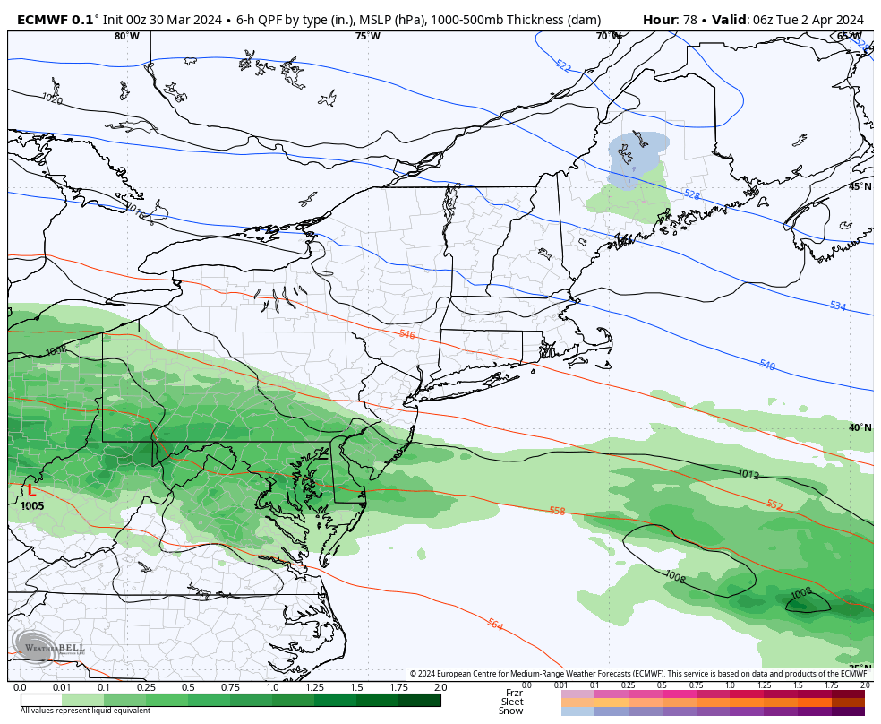
A warm front moves through the region later Monday night and Tuesday, which coincides with the most concentrated period of steadier and heavier rain. This warm front is tied to low pressure moving toward the region via the Ohio Valley. The low is expected to run into a pre-established block and will be forced to hand off its energy to a secondary coastal low Tuesday night. Rain showers will continue overnight Tuesday night and at least part of Wednesday during this process. As the secondary low rapidly intensifies near Cape Cod on Wednesday, some colder air will be drawn into the backside of that low pressure. It is possible that wraparound snow or snow showers occurs on Wednesday night and perhaps Thursday morning in our northern areas, most notably in areas of elevation.
CLICK ON ANY IMAGE IN THIS ARTICLE TO ENLARGE FOR BETTER VIEWING
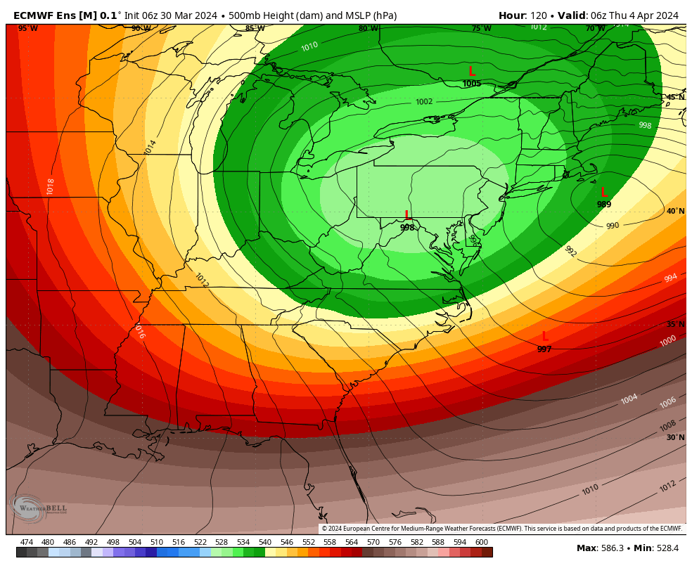
Anomalously deep trough settles into the region midweek, with chilly temps over the region relative to early April averages
Taking a closer look at precipitation type evolution with this system shows the potential change to snow for our northern areas Wednesday night into Thursday morning. This is not unheard of in April especially for the areas mentioned, and a rain/snow mix may reach as far south as the I-78 corridor in this case according to some guidance. The European model evolution for this event is below:
In terms of total precipitation, there are some variances with rain totals, but the majority of guidance is fairly similar on track and synoptic evolution. This will be a 1-2″ event for most areas, but it is important to note that the rain is falling over multiple days. The steadiest and heaviest period of rain will likely be centered around the late Monday night and Tuesday time frame, and then continuing showers after that point. Any accumulating snow locally should be confined to the vicinity of I-80 and points north, and most prevalent in areas of elevation. The snow aspect would come into play most likely Wednesday night (overnight) into Thursday morning. It is important to understand that there is only the potential for this to occur, and not a guarantee. This does have a similar look to the March 22nd-23rd system that affected interior New England with heavy snow in that area, and very minor accumulations of snow in our area nearest the PA/NY border.
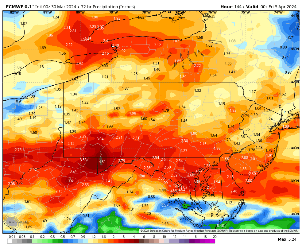
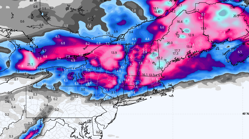
The European model guidance for this event shows potential for a general one to two inches of rain across our region, with the highest amounts in southern areas; this will be achieved over multiple days, and this is a 72 hour rain total thru Thursday evening
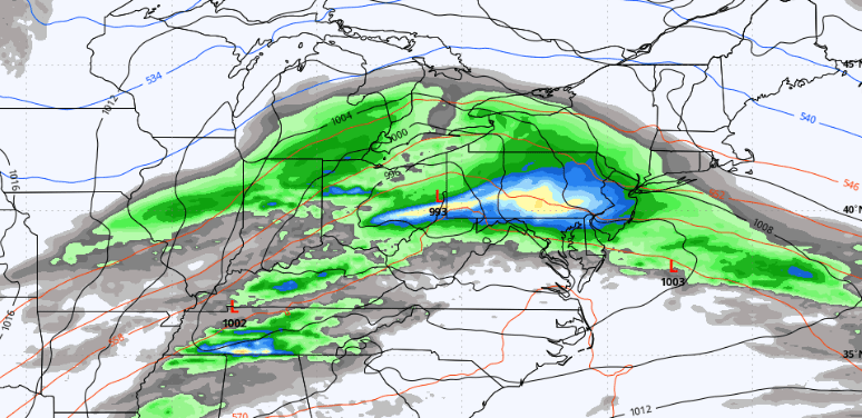
The snowfall potential for this event for the entire NE US is shown, and for interior New England snow could be significant once again. Similarities to the 3/22-3/23 event:

Zooming in on our region specifically, we have this for total snowfall:
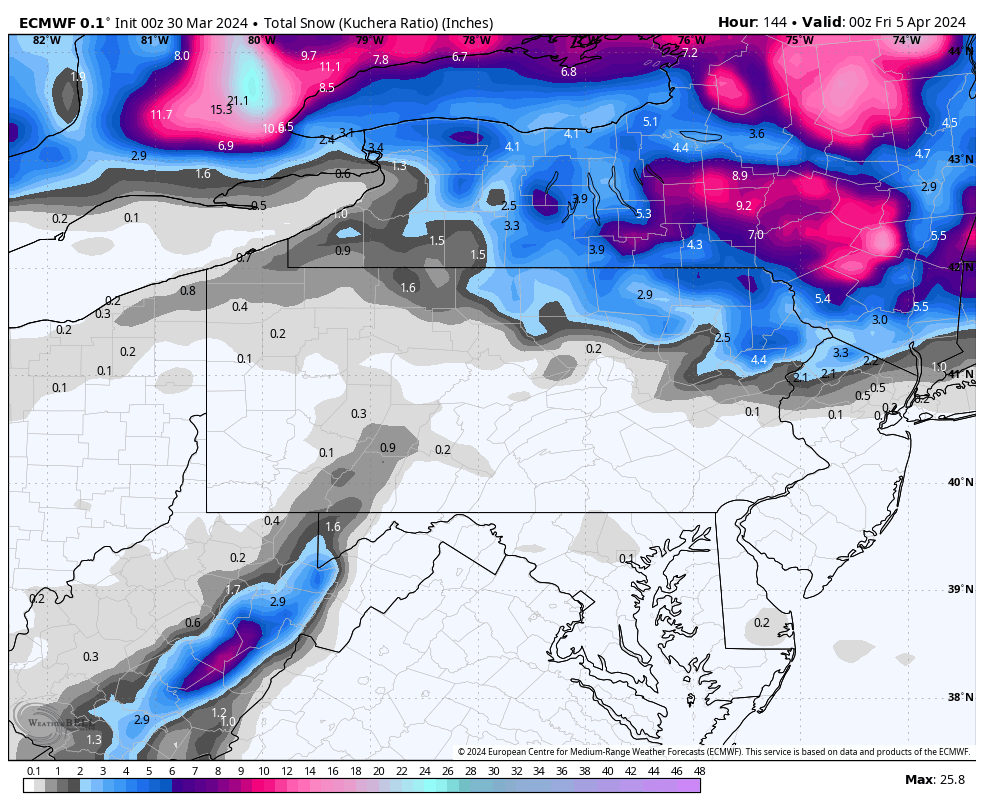
The European model guidance for this event shows the potential for minor snow accumulations across mainly the higher terrain of Northeastern PA and far NW New Jersey around the back side of low pressure, mainly from Wednesday night – Thursday AM
Any cold shots this time of year are relative to seasonal averages, and in early April those “normal” high temperatures are generally found in the middle to upper 50s. Temperatures for many areas will be stuck in the 40s in the Tuesday through Thursday time frame especially. This is a result of a well established blocking pattern and an anomalously deep trough settling over the region this week. The entire work week in fact will remain below average between Monday and at least Friday.
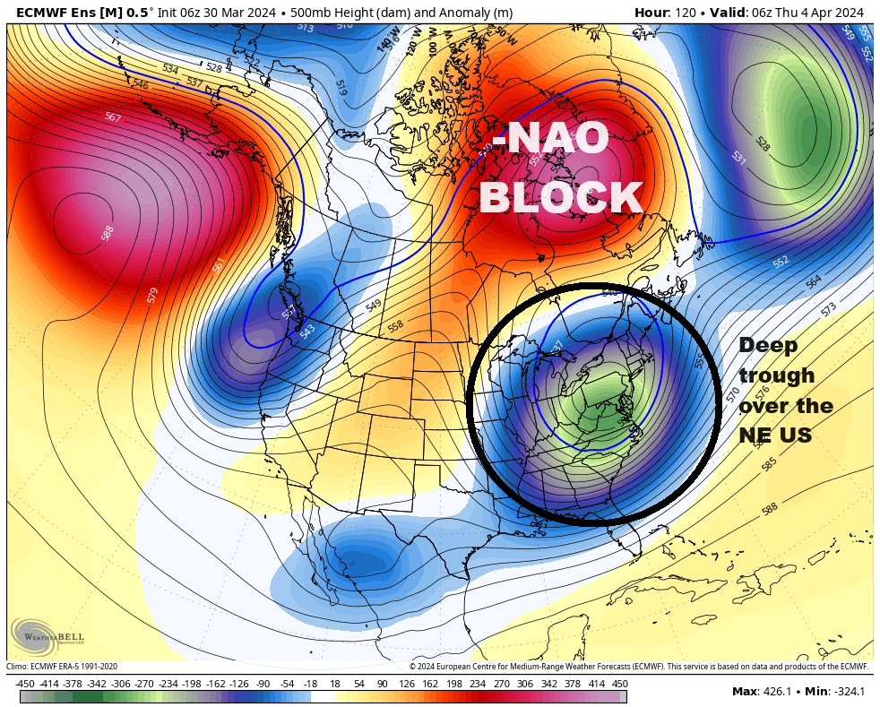
The primary reason for colder temperatures relative to average is a deep trough that undercuts a blocking pattern near Greenland and Baffin Island mid-late week
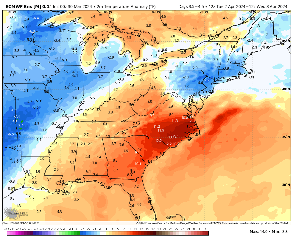
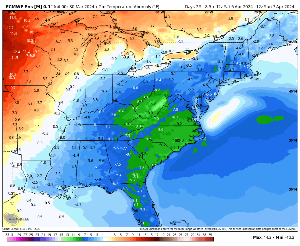
Looking at actual temperature anomalies this week, we can easily see the cooler than average temperatures settling over our region, and these are solidly below average:
For those looking for actual springlike temps, there is cause for optimism, and you won’t have to wait too long. According to this week’s public long range outlook, issued on Friday March 29th, EPAWA projects a turnaround after this week. Our long range outlook (https://epawaweather.com/long-range-outlook) shows temperatures recovering next weekend, then a slightly above to above average work week follows that may extend into the following weekend. The ensemble guidance for week 2 of April continues to suggest this idea after next week’s trough finally exits:
Of course these temperature anomalies will also be relative to average highs/lows during the 2nd week of April. Since average highs are in the lower 60s during the 2nd week of April, we could be talking about challenging or exceeding the 70° mark at different points that week. Until then, get ready for a chilly and wet start to the month of April.
