Weekend system to bring thump of snow to ice to rain
Last updated: 4:50 PM Friday February 14th, 2025
Overview:
Another system will approach the region on Saturday, and thanks to a rather large and relatively strong high pressure anchored to our NE and E, this will provide enough cold air damming at the onset to promote a wintry start. The high will be in the process of weakening and retreating, and eventually strong low pressure will cut to the west of the region Saturday night and Sunday. This will allow cold air advection to work in aloft, changing snow to sleet, then freezing rain (eastern and southeastern areas snow to rain) and eventually all areas will change to rain by Sunday morning. Before any changeover from snow to other precipitation types occur, a "thump" of front end snow will occur, incrementally increasing the farther NE one travels within our region. Far Southern areas of the Delmarva will feature mostly rain from start to finish.
As the system passes Sunday late afternoon, a strong cold front is dragged through the region Sunday evening. A tight pressure gradient will likely lead to windy conditions Sunday night and Monday with wind gusts of 25-35mph common and peak gusts to 40-50mph possible. Temperatures will also fall off quickly Sunday night, and while there could be some black ice concerns in spots, the windy conditions expected should help to dry roadways and walkways fairly quickly after rain ends late Sunday afternoon.

Impacts and Timing:
Impact level for this event is minor for interior areas expecting accumulations of snow/sleet and light icing, and minor for areas expecting freezing rain and rain.
Timing is generalized for the region, but expect precipitation regardless of type to overspread the region from SW-NE from late morning through mid afternoon Saturday, changing to other precipitation types late afternoon through evening also from SW to NE, then eventually rain during the overnight hours, ending from W-E as rain late Sunday afternoon. There is a possibility for far northern area to hold onto icing concerns into Sunday morning, especially in the highest elevations.
Snow impacts: Minor for most areas, and a bit more significant in northeastern portions of our region, most notably areas D and E on the accompanying snow/sleet map below
Ice impacts: Minor; most areas see less than 0.10" of ice accrual (which is still hazardous) and higher elevations and far W areas can see as high as 0.20"
Rain impacts: Minor for most areas, with the highest rain totals found along and near the I-95 corridor and points south where 0.75-1.25" is possible
Wind impacts: Wind will be relatively calm throughout the event but will increase considerably Sunday evening through Monday as the cold front passes through the region, NW 25-35mph and peak gusts 40-50mph possible at times
Travel disruptions: Treacherous travel is widely expected in areas D, E, and F especially with the threat of snow initially, then icing/freezing rain on untreated surfaces
Power outage concerns: Minimal and spotty during the event. Power outages will be more common Sunday night and Monday with the higher wind gust concerns
School cancellations/delays: N/A since this event is occurring over the weekend, but sporting events Saturday afternoon and evening could be cancelled
For more specific and advanced timing, impacts, and amounts by location for all future Winter storm events, including real-time updates specific to your county, click on the MPM link below for more information and to sign up.
My Pocket Meteorologist information page: https://epawaweather.com/mpm
Snow and sleet map is below, grouped together since both accumulate
CLICK MAP IMAGE TO ENLARGE FOR BETTER VIEWING


Freezing rain/ice map is below, and is separate since ice accretes
CLICK MAP IMAGE TO ENLARGE FOR BETTER VIEWING

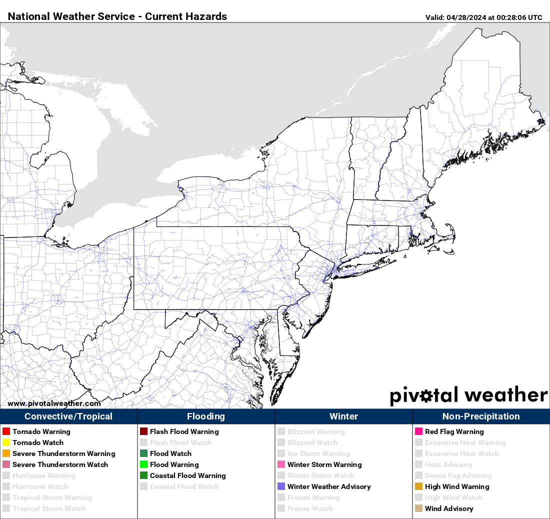
Current NWS Alerts
3km 18z NAM simulated p-type loop

Forecasters: Martrich, Rinaldi, Carmella
Last updated: 4:50 PM Friday February 14th, 2025
This is the final expected update for this system
Current Conditions
Interactive Radar

Long Range Outlook

Weather Alerts and Maps
Our Sponsors


