Southern NJ Beaches Forecast
Marine Forecast Discussion
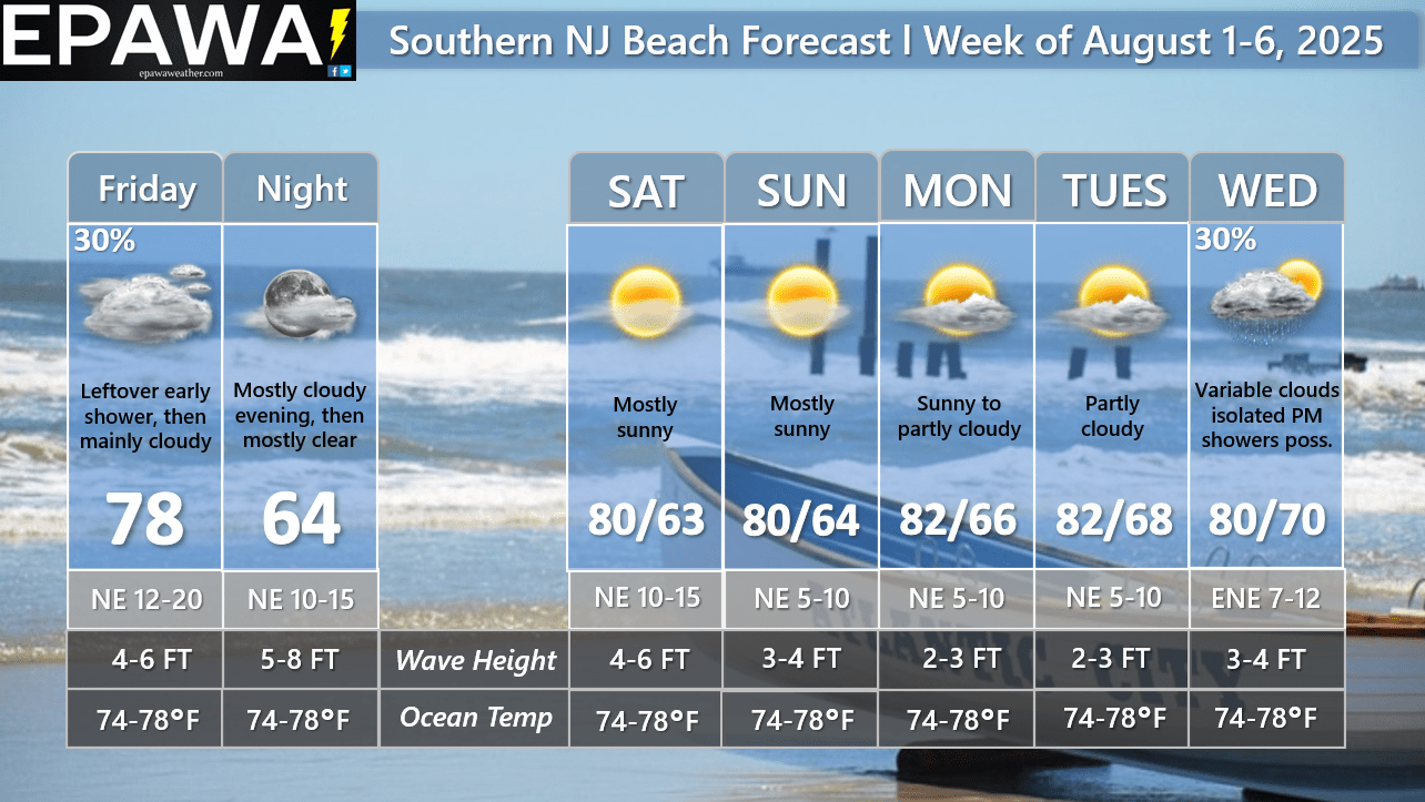
Forecast: The forecast period begins with a cold front in the vicinity earlier in the day Friday, which will continue off to the south Friday afternoon and evening. A leftover shower is possible in spots early, then remaining generally cloudy in the afternoon. As the front continues farther to the south, skies will become mostly clear overnight. High pressure will dominate the weekend with mostly sunny skies, cooler temperatures, and lower humidity both Saturday and Sunday. It remains partly to mostly sunny Monday with still lower humidity, then dewpoints will increase a bit Tuesday and Wednesday. The stalled boundary to our south may have low pressure form along it and approach the shore points by Wednesday, leading to an isolated shower(s) threat later in the day and night.
Tropical concerns: No tropical cyclone threats are forecast in the coming week.
Marine: Seas currently feature approximately 2-3 ft. wave heights with a southerly swell, and a dominant period of 3-5 seconds. Wave heights will increase to 4-6 ft. Friday and peaks at 5-8 ft. Friday night as a cold front continues through the region, and surface wind picks up with some gusts to 25mph possible through Saturday. A slightly decrease in wave heights to to 4-6 ft. on Saturday, then further gradual lowering to 2-3 ft. by early next week as high pressure dominates over the region. Thunderstorms can provide localized rough boat and beach conditions higher than wave heights indicated, and you should monitor statements issued by the National Weather Service forecast office in Mount Holly, NJ for the latest marine advisories. At present time, thunderstorm activity is possible Wednesday PM (isolated threat) within this forecast period. Ocean water temperatures will continue to run near seasonal average for this upcoming week in the mid to upper 70s.
Forecaster: Rinaldi
Last updated: 12:40 PM Thursday July 31st, 2025


Current Conditions
Interactive Radar

Long Range Outlook

Weather Alerts and Maps

Our Sponsors


