El Niño transitioned to ENSO-neutral this summer, but La Niña not so much…
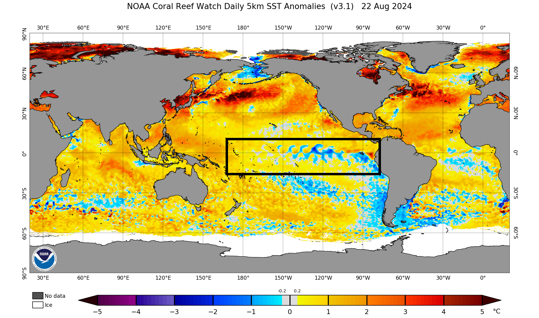
Several months ago, as recent as late Spring, longer-term climate guidance, both dynamical and statistical, expected a relatively smooth transition to La Niña by late Summer. While a transition did in fact occur from the [previous] El Niño background state to an ENSO-neutral pattern this Summer, earlier projections from the aforementioned climate guidance largely expected a transition to La Niña by now. Instead, equatorial sea surface temperatures (SSTs) are above average in the western Pacific, near average in the east-central Pacific, and below average in the eastern Pacific Ocean. This balances to a solid ENSO-neutral pattern that is very much going strong through late August.
CLICK ON ANY IMAGE IN THIS ARTICLE TO ENLARGE FOR BETTER VIEWING
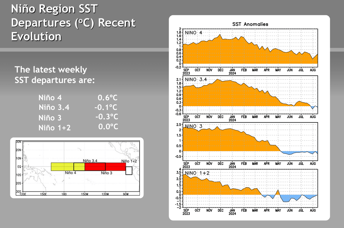
The Climate Prediction Center (CPC) weekly ENSO evolution shows a balance of Sea Surface Temperatures (SST) across the equatorial Pacific regions, which indicates a solid ENSO-neutral pattern that we are still very much stuck in though the end of the 3rd week of August.
La Niña is the counterpart to El Niño, both of which are part of the larger El Niño-Southern Oscillation (ENSO) cycle. During La Niña events, trade winds strengthen, pushing warmer surface waters toward the western Pacific and allowing cooler waters to upwell along the eastern equatorial Pacific. The ENSO-neutral phase occurs when sea surface temperatures in the central and eastern tropical Pacific Ocean are close to average, and neither El Niño (warmer-than-average sea surface temperatures) nor La Niña (cooler-than-average sea surface temperatures) conditions are present. During ENSO-neutral periods, the influences of El Niño and La Niña are absent, leading to less predictable weather patterns compared to the more pronounced conditions seen during these phases. The most recent update from the dynamical and statistical models from August 2024 are now backing off the transition to La Niña until later in the Fall… and in some cases entirely:

Growing support for a weaker La Niña at best through late Fall and Winter
As the graph shows above, the mean of the dynamical models (solid red line) shows a weak La Niña pattern being achieved closer to late October or November, which carries through the Winter months. ENSO-neutral is anywhere between +/- 0.5°C anomalies in the equatorial Pacific regions where we are currently. La Niña begins when Sea Surface Temperature anomalies (SSTa) are greater than -0.5°C below average. The dynamical models in this case takes the average SSTa to about -0.6°C to -0.7°C which would be a very weak La Niña during the Winter months. The statistical model average however (solid green line) keeps the ONI index in ENSO-neutral territory… on the positive side of zero, but an ENSO-neutral pattern nevertheless.
The overall trend has been not only to kick the can down the road on a transition to La Niña, but also to back off considerably on strength… that is even if it is reached at all. There was a time at the end of last Winter that the same models suggested a moderate La Niña would be present for the following Winter (this coming season) which left snow lovers moaning and groaning at the time. These same models projected a La Niña Summer, which if realized, would have likely increased tropical activity considerably. To date, there have been only 5 named tropical cyclones this season, and none expected to develop through the remainder of August. So early projections done in Spring from NOAA and others were based largely on the La Niña pattern being present during the active season.
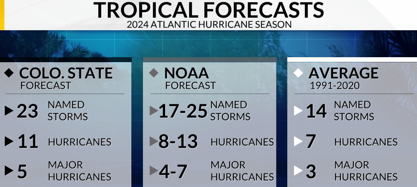
Tropical forecasts presented in Spring were quite aggressive for this season, with the expectation of a La Niña pattern during the peak of Hurricane season. Projections likely fall short considerably unless there is a quick turnaround in September
Autumn Weather Characteristics in an ENSO Neutral Pattern
Since the ENSO-neutral pattern will likely continue for at least the first half of Autumn, let’s take a look at the implications and characteristics of an ENSO-neutral pattern in the Mid-Atlantic:
Temperature Trends: In an ENSO-neutral Autumn, temperature trends in the Mid-Atlantic can be quite variable. Without the influence of El Niño or La Niña, autumn temperatures may fluctuate between warmer and cooler periods that are typically more transient. Some years may see extended warm spells, while others might experience early cold snaps. This variability can be attributed to other climate drivers such as the North Atlantic Oscillation (NAO) and regional weather patterns.
Precipitation Patterns: Precipitation during an ENSO-neutral Autumn can also be inconsistent. The absence of strong ENSO signals means that rainfall patterns may not align with the typical patterns observed during El Niño or La Niña years. This variability can lead to periods of above-average rainfall followed by drier spells. In September, for example, we expect drier overall conditions for the month.
- Rainfall: Rainfall may be sporadic, with some regions experiencing heavy rains and others receiving less. This variability makes it that much more important to stray away from seasonal forecasts, and focusing instead on shorter time periods, such as our 5-6 week lead times that we present in our Friday long range outlooks. Even beyond a few weeks in advance can be challenging.
- Hurricane Activity: Early Autumn is also the peak of the Atlantic hurricane season. An ENSO-neutral phase can affect hurricane development and trajectory, though the impact is less pronounced than during El Niño or La Niña events. Overall, ENSO neutral favors less activity in the tropics, and a large contributor to the limited activity so far this year.
Foliage and Agricultural Impacts: The changing weather patterns can have notable effects on the region’s famous autumn foliage and agriculture:
- Foliage: The timing and vibrancy of fall foliage can be influenced by temperature and precipitation patterns. Unpredictable weather conditions can lead to variations in the timing of peak leaf color and the intensity of autumn colors. So predicting this activity this Fall will be more difficult, but the earlier drought conditions (which have since abated) should theoretically lead to an earlier color change to the leaves and subsequent shedding of leaves.
- Agriculture: Farmers may face challenges due to the variability in temperature and precipitation. Unpredictable weather can impact the harvest of crops such as apples and pumpkins, potentially affecting yield and quality. Unexpected early frosts could impact crops as well, but this is more likely to occur beyond September.
Interesting mid-August table from IRI Model-Based Probabilistic ENSO forecasts:
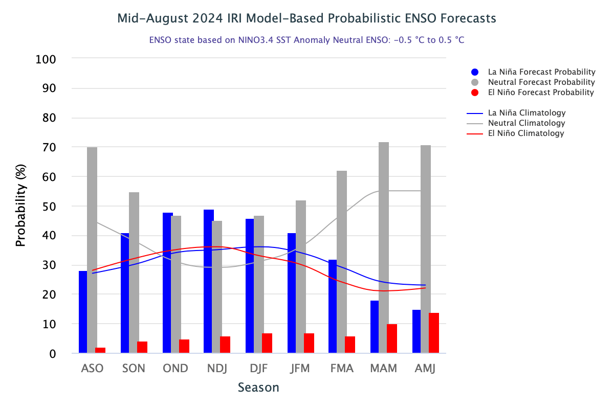
First thing that jumps out here is the La Niña pattern and ENSO-neutral patterns aren’t much different from each other in terms of probability in late Fall. La Niña holds a slight edge yet from a probability standpoint, but then ENSO-neutral takes that edge away during the Winter months. Since there has been a clear trend toward a weaker La Niña than previously expected, and the possibility that it may not even be reached, this will make Winter seasonal forecasts even more difficult to predict. We do not engage in seasonal forecasts of any kind or for any season, but many release Winter outlooks well in advance which are usually for entertainment purposes. This year will be even more difficult to verify Winter outlooks for the same reason noted above for Autumn in the Mid-Atlantic: unpredictability. We will get into a Winter impacts based on background state in a few months when this is better known, but ENSO-neutral Winters can be feast or famine:
Annual snowfall over the past 20 years at our centermost point of our region, Allentown, PA:
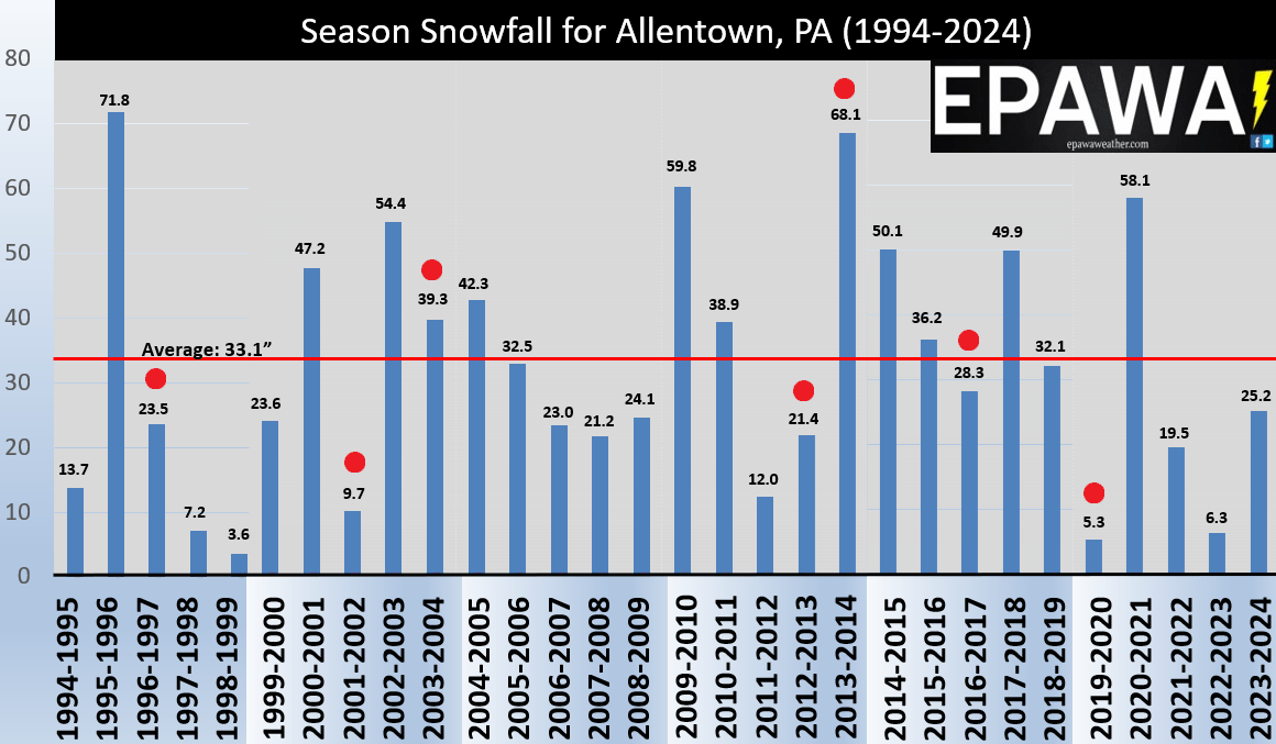
In the chart above, we used Allentown, PA since it is the centermost point of our coverage region, which covers the eastern 2/3rds of Pennsylvania, all of New Jersey, all of Delaware, and northern and eastern Maryland. This is of course one location, but the ENSO-neutral years within the past 20 years are marked with a red dot, and there have been 7 of them. First takeaway here is there is an enormous variability in snow totals… 2 above average snowfall years, and 5 below average years. A spread of as little as 5.3″ of snow in an entire season (2019-2020) and 68.1″ in the 2013-2014 season. Clearly the ENSO-neutral background state makes no clear distinction and is unpredictable. In all of those years, the end-result of mild vs. cold and snowy vs. not were primarily determined by other factors, such as high-latitude blocking, the polar vortex, the SE ridge, western US ridging, among others. There are no conclusions to be drawn if we remain in ENSO-neutral this Winter, and even more of a reason to avoid taking Winter outlooks that will undoubtedly pop-up over the next few months very seriously.

Conclusion:
There is a clear trend toward a weaker La Niña at best in the coming months, which is more likely to occur in mid-late Autumn. There is a possibility that it never reaches La Niña and remains in a positive ENSO-neutral pattern which would mean higher than usual unpredictability of longer-term patterns. We will continue to monitor the ENSO background state over the next several months, and will continue to limit long range lead times to 5-6 weeks as well always do. Take seasonal forecasts that are published and distributed with a huge grain of salt until at very least the ENSO background state is better known… especially if we remain in ENSO-neutral through the Winter months. Autumn is fast approaching, and foliage season will be upon us. We’ll do our best to guide you through the shorter-term variability of weather as it arises, and we’ll worry about the prospects of Winter when it comes.