OVERVIEW: After back-to-back very wet months relative to average in both December and January, the month of February finished on the slightly drier side of average, however it does appear evident that March will turn wetter once again. The month of March using longer range ensembles and global trends suggests a slightly above to above average precipitation (+0.5" to +1.5") departure for the month as a whole, but given the milder temperatures expected for at least in the first three weeks of the month, snowfall expectations are below average. Temperatures likely turn colder turn late month, but it will be relative to milder average highs at that time, which are solidly in the 50s. Accumulating snow, while certainly not out of the question, is more difficult to achieve at that time, especially for southern and SE areas. Our opening bid for the month of April is for a near average (-0.5" to +0.5") precipitation departure, with below average (or none) snowfall.
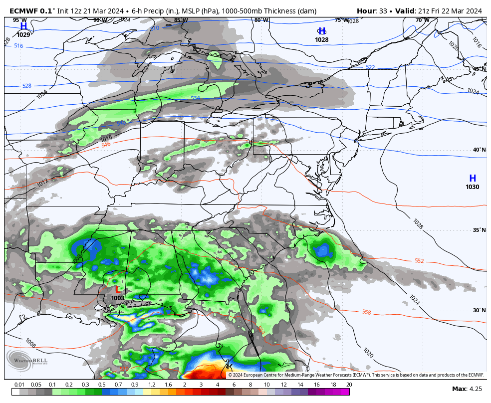
Shorter term, a system will move from the Mississippi and Tennessee valleys Friday to the Delmarva on Saturday. Showers begin later Friday night, then periods of rain are expected most of the daylight hours on Saturday, wrapping up late afternoon with moderate rain amounts. A somewhat similarly tracked system follows a few days later in the late Wednesday or Wednesday night and Thursday time frame, and may be a bit more amped than the previous [Saturday] system. This too will be in the form of rain as temperatures will be unsupportive of wintry precipitation at this time. The 3rd system listed in this week’s long range chart is for the March 9th-10th period, and has been there has been speculation this week that this may turn wintry, but we just don’t see it. It is a Miller B type system involving a transfer of energy from a primary low cutting into the Great Lakes to a secondary near the Delmarva. But with antecedent milder temperatures in place prior to the system’s arrival and no cold air source in this case, this is likely to be in the form of rain once again. Ensembles overwhelmingly agree that temperatures will be [at best] near average, which isn’t going to cut it for snow for most areas. We’ll monitor of course, but this time of year snow lovers are often looking for something…anything to hold on to, doing their best Kate Winslet in the freezing cold waters reluctant to let go of Leonardo DiCaprio after the Titanic already sunk impression. Sometimes it’s just time to move on.
Our projection for the month of March as a whole was maintained this week for slightly above to above average (+0.5" to +1.5") precipitation (or liquid equivalent) along with below average snowfall. After a slightly drier than average February, we return to the wetter look that was common in January. The month of April as a whole was introduced this week for a near average (-0.5" to +0.5") precipitation departure, and we expect below average snowfall or none at all – which typically isn’t much to begin with in April.
Breakdown of precipitation departures from normal over the next several weeks:
March 2nd – March 8th: Slightly above average
March 9th – March 15th: Above average
March 16th – March 22nd: Slightly above average
March 23rd – March 29th: Slightly above average
March 30th – April 5th: Near to slightly above average
April 6th – April 12th: Near average
Public/free available maps will be updated when a threat is imminent for significant weather on the weather alerts page throughout the year: http://epawaweather.com/weather-alerts/
Note: Any image below is clickable for larger viewing