El Niño has transitioned to ENSO neutral for now, but La Niña is inevitable…
There has been a clear shift in Sea Surface Temperature Anomalies (SSTA) over the past couple of months in the equatorial Eastern Pacific from a weak El Niño background state to now an ENSO neutral state. The shift has implications on both temperatures and precipitation as we begin Summer, but the transition to ENSO neutral likely won’t stop there. A weak La Niña is expected to develop during the month of July (at some point) and carry forward into the Autumn months, and perhaps at least a portion of the Winter months. A La Niña background state, characterized by cooler-than-average sea surface temperatures in the central and eastern Pacific Ocean, has the potential to influence weather conditions around the globe. In this article, we delve into the potential effects of La Niña on the upcoming Summer weather in our local region.
CLICK ON ANY IMAGE IN THIS ARTICLE TO ENLARGE FOR BETTER VIEWING
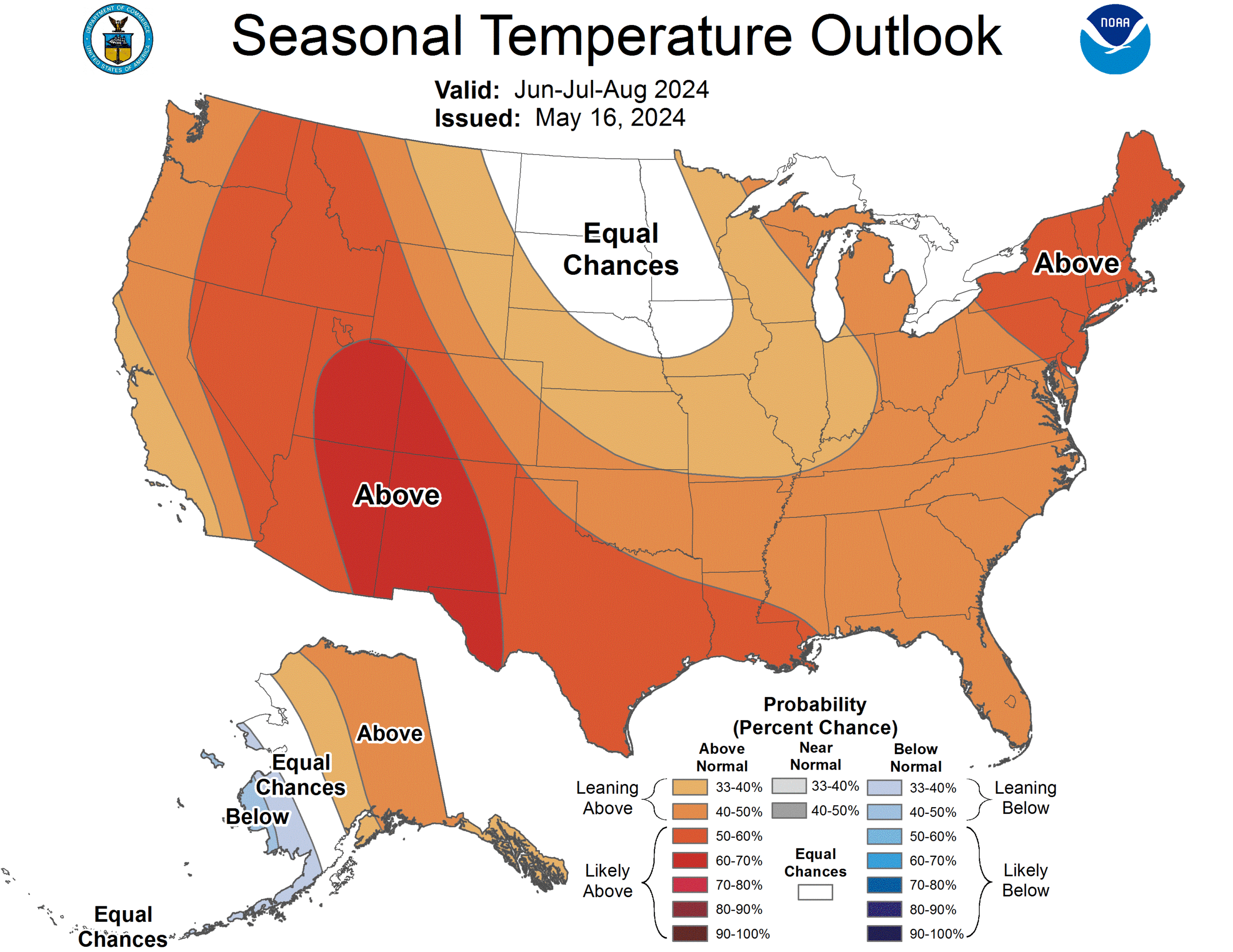
The Climate Prediction Center (CPC) projects that above average temperatures are favored over the next three months, the core summer months of June-August.
Click below for more information:
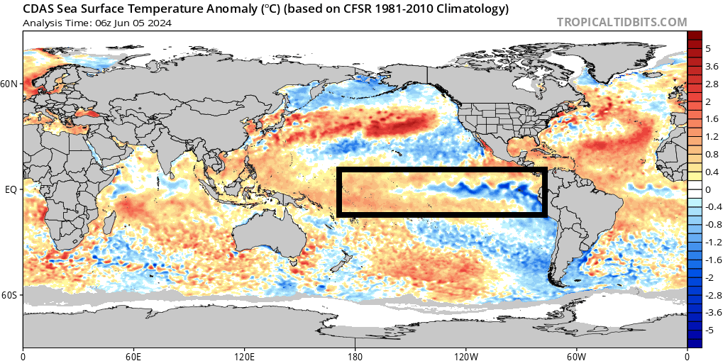
La Niña is the counterpart to El Niño, both of which are part of the larger El Niño-Southern Oscillation (ENSO) cycle. During La Niña events, trade winds strengthen, pushing warmer surface waters toward the western Pacific and allowing cooler waters to upwell along the eastern equatorial Pacific. This is currently happening (observed) in the Eastern Pacific, and will continue westward with time:
Potential Effects of a La Niña Summer pattern in our region:
Temperatures: La Niña typically brings cooler and wetter conditions to the Pacific Northwest and warmer and drier conditions to the southern United States. For the mid-Atlantic region, the effects can be more variable. While La Niña tends to favor above-average temperatures in the southeastern United States, its influence on the mid-Atlantic can be less pronounced. However, it typically contributes to warmer-than-average temperatures, particularly in the latter half of summer. In this particular year with a weak La Niña pattern to take hold sometime in July, this will likely follow that paradigm.
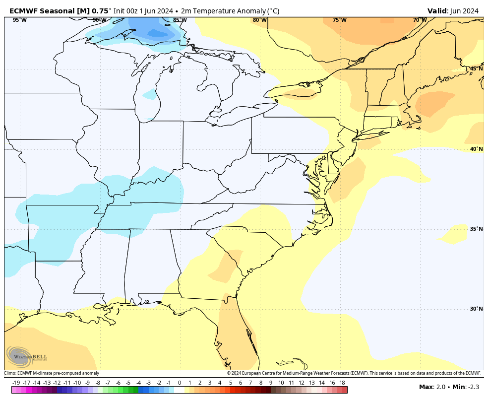
The European seasonal guidance shows the transition of temperatures from a near to slightly above average June to a more consistently warmer than average July, August, and even September as La Niña settles in
This transition will be contingent on several factors, but nothing more notable than how quickly the handoff is made from ENSO neutral to a weak La Niña background state. Should this transition in any way be delayed, it would also limit some of the heat and extreme heat events to later in Summer. However the current expectation from EPAWA and the CPC is for a transition sometime in July:
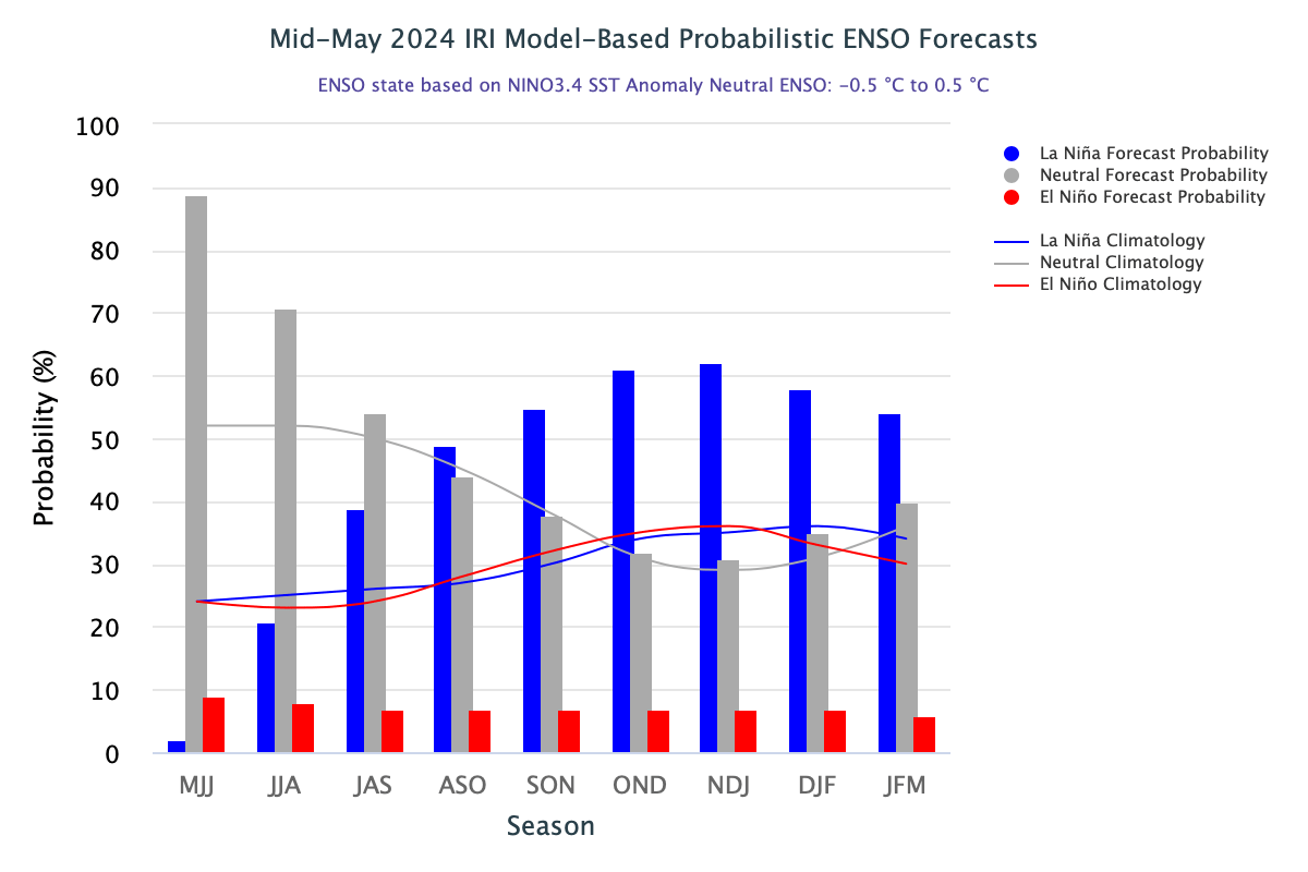
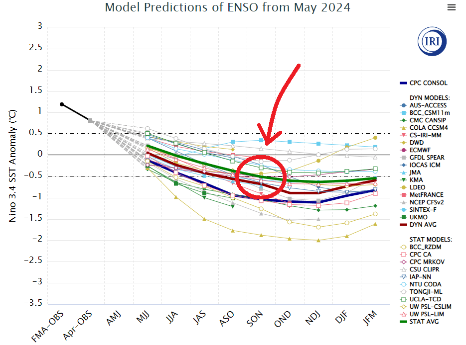
The model projections of ENSO from May 2024 suggest that while La Niña will eventually be reached, it may take some time getting there. ENSO neutral summers favor warmer conditions, but also wetter than a La Niña pattern.
Potential Effects on the Mid-Atlantic:
Precipitation: One of the key impacts of La Niña on the mid-Atlantic is its influence on precipitation patterns. The region tends to experience below-average precipitation during La Niña events, which is different from an ENSO neutral pattern that typically favors wetter than average conditions. However, the effects on rainfall can vary depending on other atmospheric and oceanic factors, making it challenging to predict with certainty. Hot and dry Summers are usually attributed to a La Niña Summer pattern, but like with temperatures, a delay in the onset of La Niña will also delay drier (overall) weather.
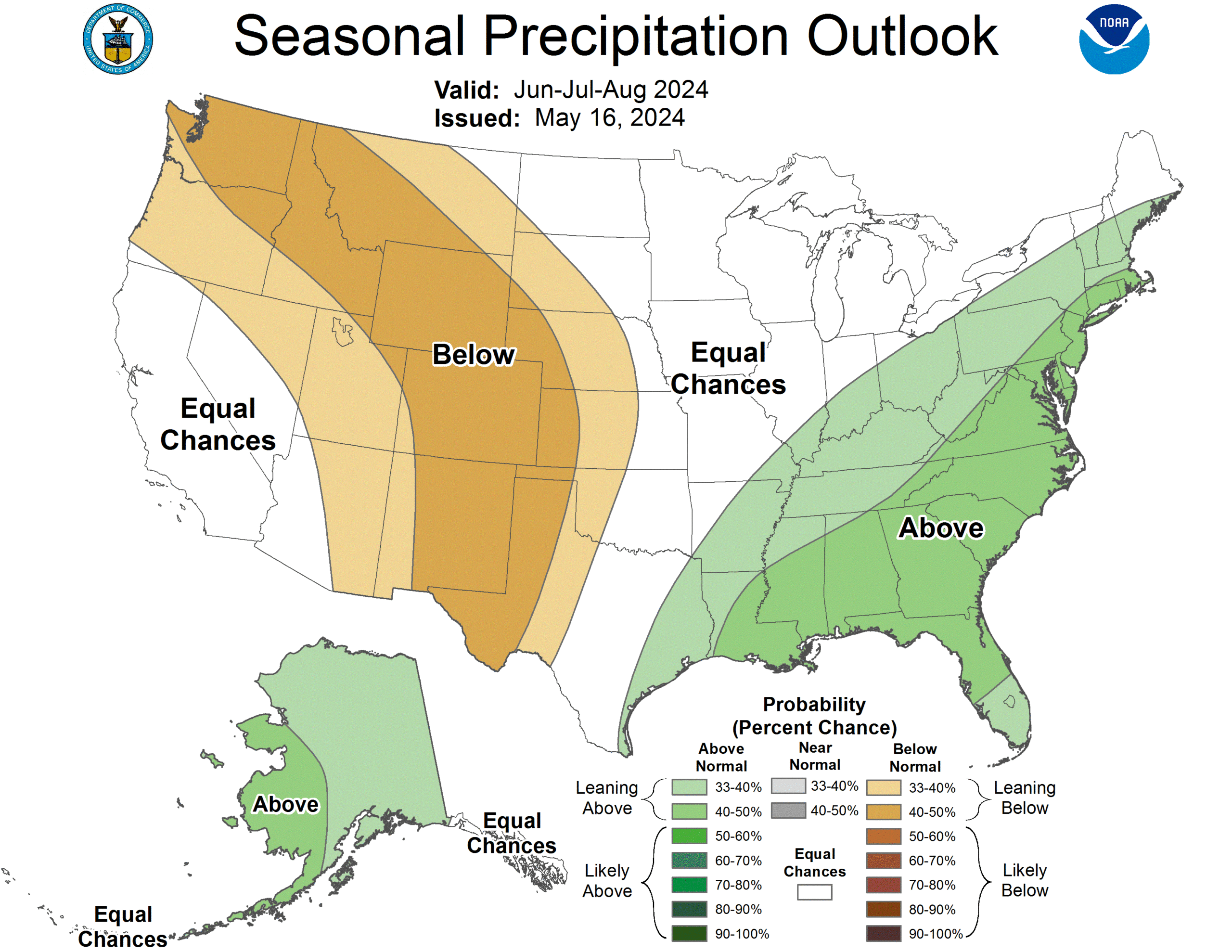
CPC predicts above average precipitation Jun-Aug with La Niña settling in later
Potential Effects on the Mid-Atlantic:
Tropical Cyclone Activity: La Niña can also influence tropical cyclone activity in the Atlantic Basin. While it tends to suppress hurricane activity in the eastern Pacific, it can enhance the effects in the Atlantic. This means that the mid-Atlantic region could face an increased risk of tropical storms and hurricanes during La Niña summers. Warmer than average sea surface temperatures in the main development region of the tropical Atlantic waters provides fuel for tropical development.
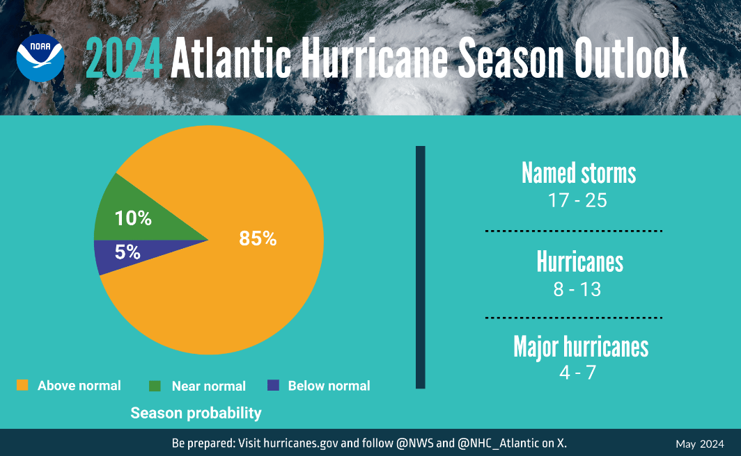
NOAA predicts an above-normal 2024 Atlantic hurricane season
Potential effects on the mid-Atlantic:
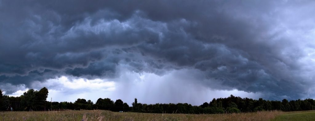
Severe Weather: In addition to tropical cyclones, La Niña can enhance the risk of severe weather events, which are stronger thunderstorms that have the ability to produce damaging straight-line winds, hail, and even tornadoes. The increased instability and moisture in the atmosphere can fuel the development of these storms, and that is also true of ENSO neutral Summers to some degree. As temperatures increase, the convective available potential energy (CAPE) also rises. which is a key component in thunderstorm development in general. Although not forecastable on a longer term basis, the probability of severe weather is enhanced typically in a La Niña Summer. So far this year, we have seen limited severe activity across the region as a whole, but expect that activity to pick up a bit as we starting getting into more consistent hotter and humid conditions.
As La Niña exerts its influence on global weather patterns, our region’s potential impacts on summer, while they may not be as pronounced as in other parts of the country, could still contribute to above-average temperatures, below-average precipitation, and an increased risk of tropical storms and severe weather. But any delay in its arrival to late Summer or early Fall will delay those effects. It is still our opinion that the transition will occur sometime in July, and we will monitor it closely.
