Ocean City, MD and DE Beaches Forecast
Marine Forecast Discussion
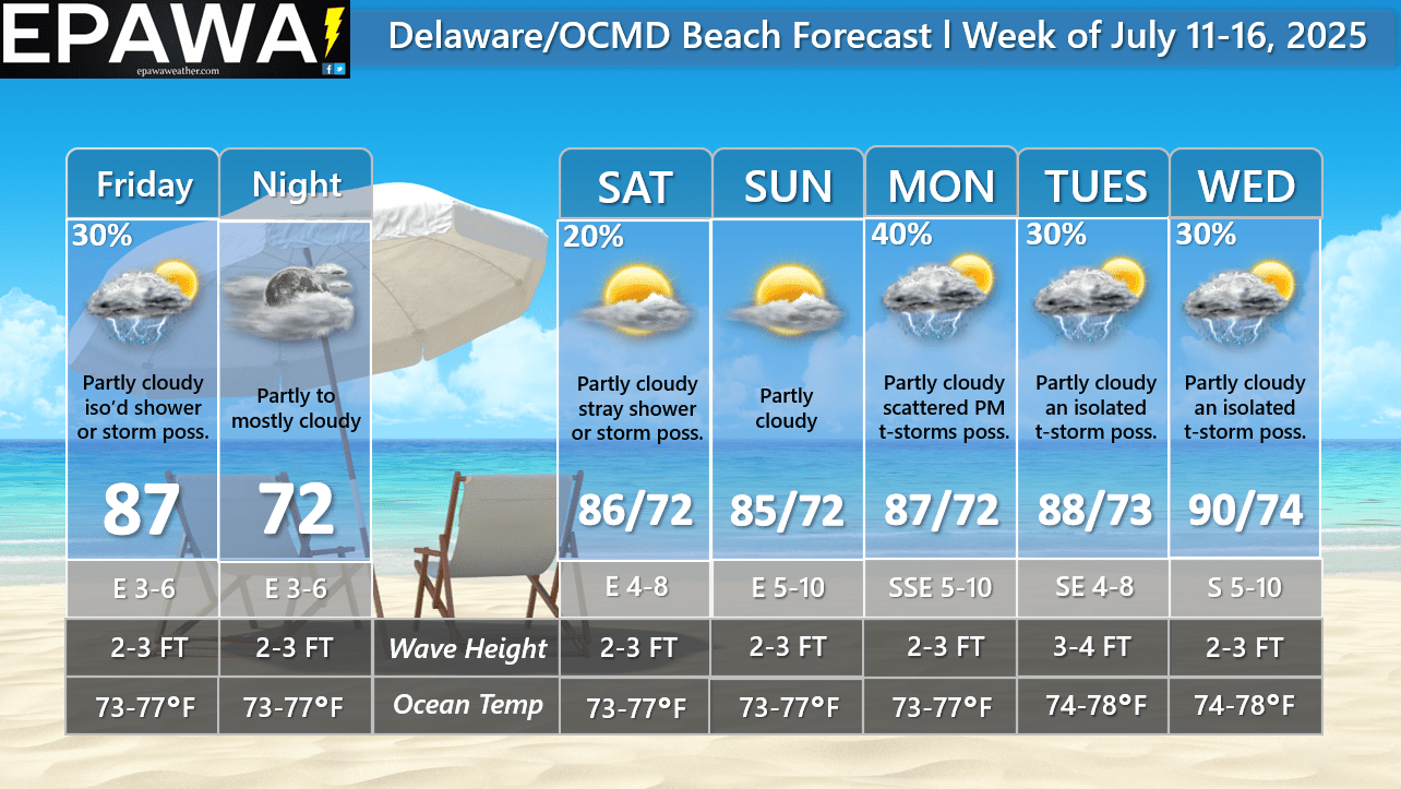
Forecast: The forecast period begins with a boundary in the vicinity that will wash out by Saturday as Bermuda high pressure weakens. Due to its relative close proximity and some weak disturbances moving through, an isolated shower or t-storm will be possible Friday, then more of a stray threat Saturday afternoon, but most of the time is dry with partly cloudy skies expected. By Sunday that same front dissolves, and precipitation mentions were removed from the forecast. A cold front will move through later Monday leading to scattered PM showers and thunderstorms, then clears Monday night. The front will remain nearby to the SE Tuesday and Wednesday, and partly cloudy conditions are expected with hotter temperatures, but still a risk for an isolated afternoon thunderstorm each day.
Tropical concerns: No tropical cyclone threats are forecast in the coming week.
Marine: Seas currently feature approximately 3-4 ft. wave heights with a southeasterly swell, and a dominant period of 6-8 seconds. Wave heights will lower to 2-3 ft. Friday, then maintain those wave heights throughout the upcoming weekend, An increase to 3-4 ft. on Tuesday in the wake of a cold front moving through the region late Monday. Thunderstorms can provide localized rough boat and beach conditions higher than wave heights indicated, and you should monitor statements issued by the National Weather Service forecast office in Wakefield, VA for the latest marine advisories. At present time, thunderstorm activity is possible late Friday and Saturday (isolated/stray threat) and Monday (scattered threat) and Tuesday-Wednesday (isolated threat) within this forecast period. Ocean water temperatures will continue to run near seasonal average for this upcoming week in the middle 70s.
Forecaster: Rinaldi
Last updated: 9:50 AM Thursday July 10th, 2025


Current Conditions
Interactive Radar

Long Range Outlook

Weather Alerts and Maps

Our Sponsors


