
In 2013, EPAWA introduced the premier economical service, My Pocket Meteorologist (MPM). Ever since its start, everyone from large companies to everyday weather enthusiasts have been benefitting from the convenience of manual, meteorologist produced forecasts sent directly to their phone. EPAWA entered into a joint-venture partnership with WeatherNJ in 2016 to become the largest and most reliable supplier of text alerts, daily forecast texts, and joint Premium Forum in the NE US and Mid-Atlantic! The same great service that you have come to trust over the past few years got even stronger with the partnership with Jonathan Carr and his associates of WeatherNJ, LLC.
Whether you’re a contractor, landscaper, facility manager, or someone who just doesn’t want to be stuck in the rain, snow, or ice, this service is for YOU! Please see the detailed information about each service below and choose the best one that suits your needs. We look forward to serving you with forecast accuracy, excellence, and dependability!
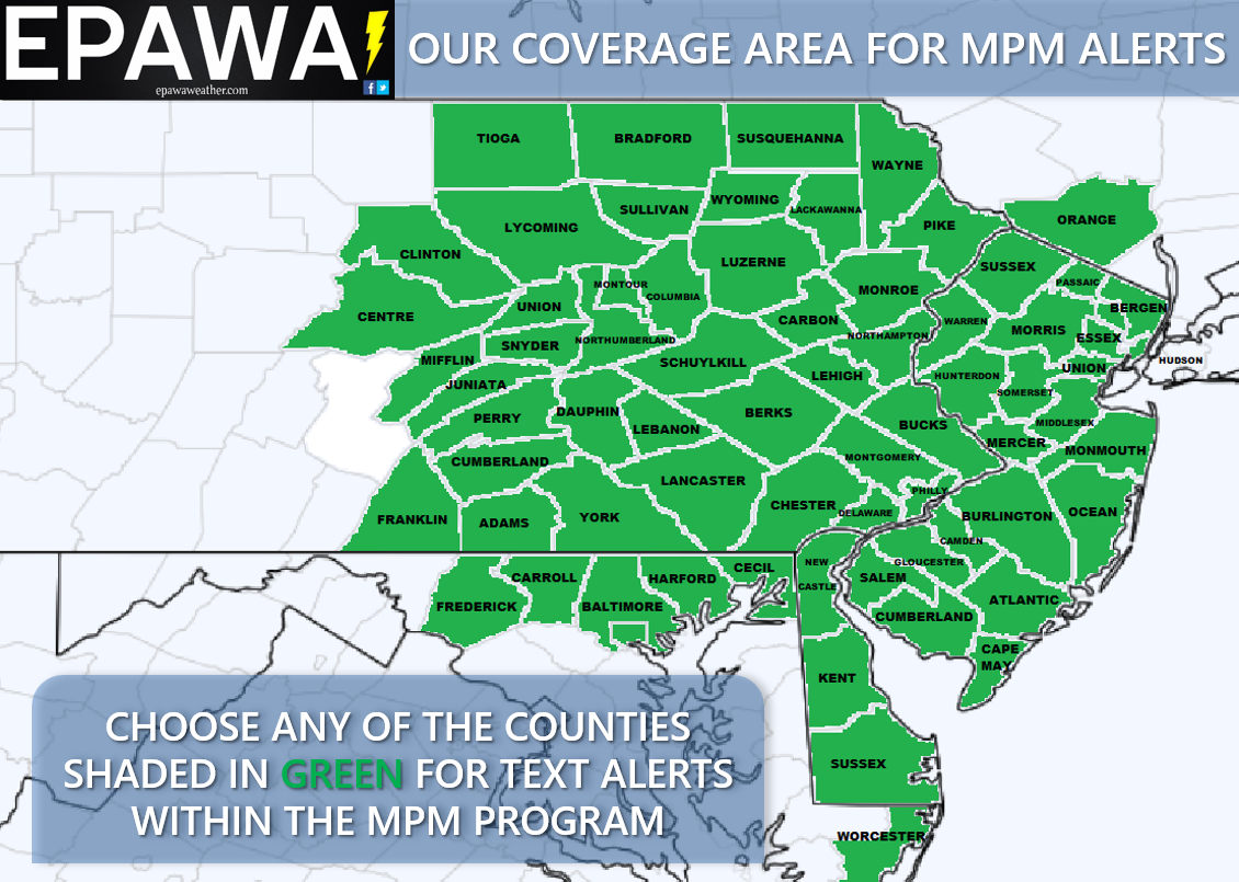
A breakdown of the counties that we cover are shown below in GREEN:
Service Overview
Your forecast alert will be sent via text directly from an on-staff Meteorologist from Weather NJ and EPAWA. Alerts vary depending on which option you sign up for—"Daily Forecast Service", or "Weather Alerts Service" (active days only).
Both services offer affordable, low monthly rates starting at just $0.20/day! Discounted semi-annual and annual options are also available!
Year-round text alerts and forum options
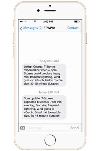
Weather Alert Service*
*Choose this option for all year-round services outside of the Winter/seasonal program
Created for those who want early warnings for any significant weather system moving into their county, the MPM Weather Alert Option provides advanced notice of:
- Strong/severe thunderstorms – On the morning of a potential severe weather day, alerts are issued on a county-level basis that provides a precise timing window for potential strong/severe thunderstorms, as well as an outline of potential impacts and realistic expectations of those thunderstorms.
- Heavy Rain – Text alerts are sent the day before a rain event when .50" of rain or greater is expected to fall within a 12 hour period
- Wind – 1 day notice for wind gusts 40mph or greater
- Tropical Systems – Up to 5 days notice of any potential impact on your county
- Winter Storms – Up to 3 days notice with daily updates thereafter leading up to the storm, and updates with any changes to previous text forecasts as needed during the storm until the storm fully passes
- Light snow (less than 3") – Text alerts are sent the day before an event with precise snowfall expectations, including updates with any changes to previous text forecasts as needed during the storm until the storm passes
- Icy Road Conditions – Any threat of ice, and for any amount
- Snow Consistency – Wet snow vs. dry/powdery
- First frost and freeze at the end of the growing season in Fall, and sent in Spring if it occurs after the growing season has begun
Great for everyone from snow removal services, school districts, and roofers to every-day commuters and persons wanting accurate information up to the minute!
*Weather alerts are typically sent to your phone between the hours of 9am and 5pm. In the case of text updates, we will never send texts past 9pm, and any updates would fall within that 9am-9pm time window.
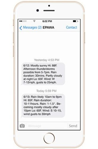
Daily Text Forecast Service
Perfect for the every-day weather curious person looking for more than your average news forecast, the MPM Daily Text Forecast Option provides the NEXT DAY forecast for your county, sent between 3-8PM the night before!
This service is sent every day, 365 days a year:
- Accurately de1picts sky condition and precipitation (type) for the next day
- Includes high and low temperatures for your area
- Provides wind speed, direction and maximum gust
Premium Weather Forum
Our premium forum is a joint forum that is managed and contributed to by EPAWA Weather Consulting and Weather NJ meteorologists. No matter what the weather, we give you the most comprehensive in-depth advanced information that you won’t find anywhere else… for the area that you care about… and the local area that we specialize in. From analysis that you won’t find anywhere publicly, we explain the hows and whys of weather systems, how it may impact the region by individual area, and discuss with the members our interpretations of model guidance with impending storms affecting our region. As a member, you get:
- Early access to Winter snow maps before the public, including advanced discussion not shared with the public
- Early access and model analysis for severe weather events, including our proprietary severe charts for your specific location
- Frequent interactive updates for all major weather systems affecting our region
- Long range outlook updates Mondays and Wednesdays in addition to the Friday public long range releases
- In-depth advance model analysis ahead of Winter storm threats that are not shared publicly
- Ask A Meteorologist Q&A
- Short and Long Range weather discussions
- Storm observations
Bundle and save! Get the daily text forecasts and Weather Alerts together for less!
Winter (Seasonal) Text Alerts
Tailored for those who want early warnings for any significant weather system moving into their specific county during the entirety of the winter season, November 1st, 2024 through March 31st, 2025, or last snowfall. All for a one-time payment of $34.99 for one county monitoring, or $44.99 for two county monitoring. The Winter Weather Alert option provides advanced notice of:
- Winter Storms – Up to 3 days notice with daily updates thereafter leading up to the storm, and updates with any changes to previous text forecasts as needed during the storm until storm passes
- Light snow (less than 3") – Texts are sent 1-2 days before an event with daily updates thereafter leading up to the snowfall, and updates with any changes to previous text forecasts as needed during the storm (in real-time) until storm passes
- Heavy Rain – Up to 2 days notice of rain reaching or exceeding .50" within a 12 hour period
- Ice Conditions – Any threat of ice, and accrual amounts
- Snow Consistency – Wet vs. dry/powdery
- Specific timing for your area, including start/end times, and changeover times to other forms of precipitation, if applicable
- Wind – 1 day notice for wind gusts 40mph or greater
All that you need: A cell phone that is capable of receiving text messages. This service is not for landline phones or email.
SPECIAL NOTE: Seasonal text alerts are a subscription-based service. Although it remains a seasonal program from November 1st through March 31st, the subscription will renew automatically the following year at the beginning of the new Winter season, November 1st. There is no longer a need to sign up manually for the service(s) every year as long as the payment source on file is current, and prior notification to cancel was not given prior to the renewal date. This applies to existing customers only, carried over from the previous season.
Current Conditions
Interactive Radar

Long Range Outlook

Weather Alerts and Maps
Our Sponsors


